Toward the end of the opening chapter of my manuscript, The Life and Times of Matthew Fontaine Maury, Pathfinder of the Seas, we find the man bedfast in his Virginia home following his life’s ambition to the bitter end to “make myself useful to my fellow man.” Though his health was failing and he knew well enough that his days were few and numbered on this mortal coil, Commodore Maury nevertheless passed the final weeks and months of his life dictating to his attendant children necessary changes and revisions to his Geography Series titled in the following order, First Lessons in Geography, The World We Live In, Manual of Geography and Physical Geography.
The purpose of this essay is not to tell the interesting story of how that series of textbooks came into being, nor of how the idea for the series was first hatched, by whom, or where; it is to introduce, or re-introduce as it were, an old method of map drawing that has unfortunately and long since gone out of vogue, and to nudge you in the direction of giving the method a try with your own kids. In our little homeschool this much beloved method has long been known as “Maury Map Drawing.”
Without further ado, let us read what Commodore Maury himself had to say as concerns the subject of our investigation. The following extracts are taken from the third in Maury’s Geography Series, Manual of Geography, beginning pg. 127.
The Object and Value of Map-Drawing.–Map-drawing, as ordinarily practiced in schools, is more correctly spoken of as map-sketching.
It does not aim to represent the features of continents and countries with accurate detail. This is the special business of the chartographer. The map drawing of schools, on the other hand, is simply an aid to the study of geography.
The pupil, by sketching maps on paper, slate, or black-board, fixes in mind more readily the facts of physical geography, the contour of countries, and their relief and drainage. A form which has been correctly delineated without assistance, must be fully and permanently impressed upon the memory. Increased interest is also imparted by this means to geographical study, because learning to represent various physical features of a country by sketching them in a map, is far more attractive to a child than studying the same features for the purpose of making an oral recitation. Progress by this method may seem slow at first, but experience proves it to be the most rapid, satisfactory, and thorough, in the end.
It is further to be observed that map-drawing furnishes an additional method of convenient and profitable class recitation. A teacher having before him maps drawn by his class, can measure the proficiency of each pupil with a degree of thoroughness not attainable under a purely oral system of recitation.
Manual of Geography, pg. 127
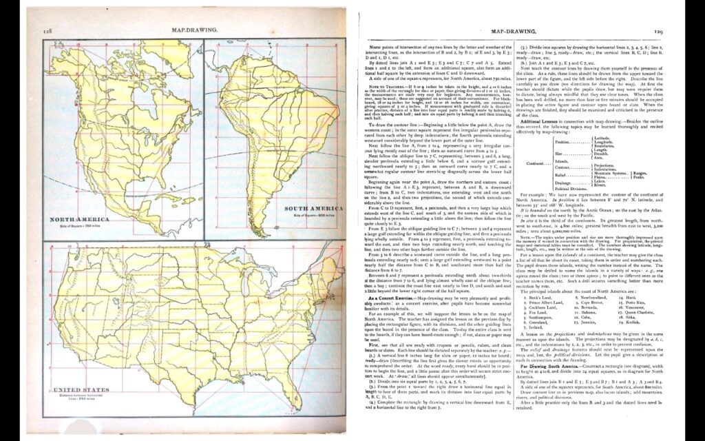
I have written before of my family’s transformation from using mass-produced pre-packaged progressive (3-R) curriculums to the exciting and truly educational “new world” (to us at the time) of whole-to-part 4-R methodology. I could write volumes on the subject and perhaps will one day when time and circumstances allow, but for the time being and for our purposes here, I should confine my own commentary to the specific subject matter of this essay. Namely, Maury Map Drawing.
I can certainly attest to the veracity of the claims made in Mr. Maury’s commentary above. When Maury was a young Passed Midshipmen beginning his illustrious career in the then fledgling U.S. Navy, Noah Webster published his first edition of the American Dictionary of the English Language. Mr. Webster defined the word “education” in that famous edition as follows:
All that series of instruction and discipline which is intended to enlighten the understanding, correct the temper, to form the manners and habits of youth, and to fit them for usefulness in their future stations.
NB the final statement in that definition – to fit them for usefulness in their future stations. This is the end of education, of true education; its goal.
As parents and primary educators of our children we can know with a reasonable degree of certainty what many of those most important future stations will be. E.g., we can know whether they are likely or not to get married and have their own families, whether or not they will be city dwellers or country folk, laborers of one sort or another, business owners or employees, members of a church and other religious institutions, and so on and so forth. The list could go on and on of course but the broad point is that as we can know what their future stations will most likely be in many instances, we can also customize their educations to prepare our children for their best usefulness in those future stations once they begin to occupy them.
Some of which or all of which may seem tangential to the subject matter under investigation, but it isn’t. “Map sketching,” as Maury so aptly denominated it, is simply a tool for teaching and learning the subject of Geography. Which, in my view, is among the most important of all subjects for kids to develop a tolerable understanding of. This is probably why it is no longer taught in the public schools, since for the next generation on the whole to possess a tolerable understanding of basic geographical principles would severely undermine the tireless efforts of the “global warming” alarmists and their dependency on government to act as their agent in transferring the wealth generated by the laboring poor into their own coffers, making ‘much ado about nothing.’ Same with the COVID alarmists, but that is another post.
While the earth remaineth, seedtime and harvest, and cold and heat, and summer and winter, and day and night shall not cease. – Gn. 8:22
A tolerable understanding of basic geographical principles is imparted to students in a variety of ways more or less effective. But as Maury iterates in the passages above, one of the most effective tools for imparting this essential knowledge (as well as one of the most enjoyable to the student himself, as Maury also points out and I can confirm) is independent map sketching. Now, map sketching itself is accomplished in a variety of ways depending on the individual student and his teacher. For the average student, however, the Maury method is the best to the purposes of map sketching in the first place. And the purpose of course is to ‘fit him for usefulness in his future stations,’ whatever those stations may turn out to be.
With the COVID scare came of course the introduction of many parents to “virtual schooling.” This presents a golden opportunity for parents not already officially homeschooling to get intimately involved in their childrens’ educations. In the particular school district in which we reside, for example, parents have the option of sending their kids to the school or doing the “virtual school” thing from home. To those parents who read this, who have that option and have chosen that option, why not supplement what little, if any, Geography lessons in your child’s curriculum with a little Maury Map Drawing? You and your child/children have nothing to lose and everything to gain by it, I can assure you as an ‘old hand’ at this. And the beauty of it is that everything you need to know to get started is right there in the pages of the book.
But I forewarn you, Maury Map Drawing is like the ‘gateway drug’ into revolutionizing your thinking on what education is and what it should be. Which is why I took the time to write this post when you boil it all down. Happy drawing!
-By Terry Morris
O I’m a good old rebel, now that’s just what I am. For this “fair land of freedom” I do not care at all. I’m glad I fit against it, I only wish we’d won, And I don’t want no pardon for anything I done.




Mr. Morris,
This is a great piece. Useful for parents concerned about the education of their children. Thank you for sharing your experiences, lessons, and knowledge – especially given what passes for “education” today.
Indeed!